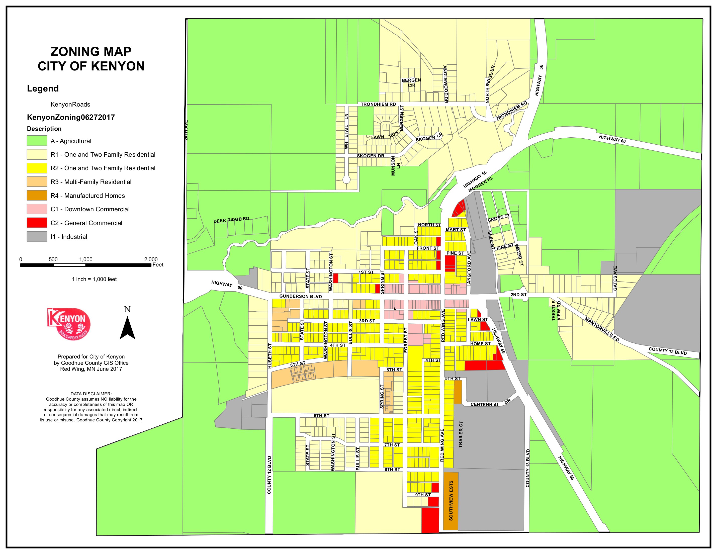
Legend
- A Agricultural
- R-1 One and two family residential (newer plats)
- R-2 One and two family residential (original plat)
- R-3 Multi-family residential
- R-4 Manufactured homes
- C-1 Downtown commercial (2nd Street)
- C-2 General commercial (Highway 60, Red Wing Avenue)
- I-1 Industrial (industrial park, rail corridor)
Map data KenyonZoning06272017, prepared for the City of Kenyon by the Goodhue County GIS Office, Red Wing, June 2017. Scale 1 inch = 1,000 feet. The county disclaims liability for accuracy; the ordinance text controls.
Rezoned since the map was drawn
Six ordinances have changed the map since June 2017, all of them moving land toward commercial or industrial use along Highway 60, Huseth Street and the industrial park. Each is a $300 application, a planning commission hearing and a council ordinance.
| Ord. | Adopted | Applicant | Where | Change | |
|---|---|---|---|---|---|
| 86 | May 9, 2017 | EDA / industrial park | North of Mantorville Road and County 12 (PID 66-120-0010, 29.58 acres) | A → I-1 | |
| 88 | June 13, 2017 | Sahl | Two parcels in Lot 9, Auditor's Subdivision, NE¼ Section 4 (27,261 sq ft each) | A → R-1 | |
| 90 | June 12, 2018 | L&M Construction | 618 9th Street (PID 66.560.0160) | R-2 → C-2 | |
| 98 | July 13, 2021 | Robert Kyllo | 19 Langford Avenue (PIDs 66.540-1380, 66-660-0101) | I-1 → C-2 | |
| 104 | June 11, 2024 | Paul and Lisa Peterson | 98 Gunderson Boulevard, two parcels (PIDs 66-180-0150, 66-180-0130) | I-1 and R-1 → C-2 | |
| 106 | October 8, 2024 | Jeffrey and Ann Traxler | 502 Huseth Street (PID 66.680.0460) | I-1 → C-2 |
What each district allows
| District | Name | Min. lot | Front | Side | Rear | Height |
|---|---|---|---|---|---|---|
| A | Agriculture / one-family residence | 2.5 acres | 30 ft | 30 ft | 50 ft | 35 ft |
| R-1 | One and two family residence | 10,000 sq ft (one family) | 30 ft (never under 20 ft where neighbors differ) | 15 ft | 30 ft | 35 ft |
| R-2 | One and two family residence | 6,600 sq ft (one family) | 25 ft (never under 20 ft) | 7 ft | 30 ft | 35 ft |
| R-3 | Multi-family residence | 4,500 sq ft per duplex | 30 ft | 8 ft (duplex) | 30 ft | 45 ft |
| R-4 | Manufactured homes | 5,000 sq ft per unit | 25 ft | 8 ft | 20 ft | 35 ft |
| C-1 | Downtown commercial | 2,000 sq ft | none | none (fire code applies) | 10 ft | 45 ft |
| C-2 | General commercial | 8,500 sq ft | 30 ft | 10 ft | 20 ft | 35 ft |
| I-1 | General industrial | 10,000 sq ft | 30 ft | 20 ft | 20 ft | 45 ft |
Full rules, accessory buildings and fences: zoning page. Check a district: zoning check tool. Find a parcel: property lookup.
Reading the map
Most of the original plat between State Street and Red Wing Avenue is R-2 (yellow). The newer plats, Whitetail Ridge and Countryside Meadow to the north and the blocks south of 5th Street, are R-1 (cream). Downtown 2nd Street is C-1 (pink); Highway 60 and the south end of Red Wing Avenue are C-2 (red); the industrial park east of Red Wing Avenue and the rail corridor are I-1 (gray). R-3 (tan) is the apartment blocks on Gunderson Boulevard and 4th Street; R-4 (orange) is Southview Estates and the Trailer Court. Everything outside the built-up area is A, agricultural, which is where annexations and the 2017 EDA rezoning start.